- Arusha Tanzania
- info@tripstanzania.com
- +255 787 497 897
Mount Kilimanjaro, a dead volcanic mountain is Africa’s tallest and is also ranked as the world’s highest free-standing mountain. Kilimanjaro trekking is also considered as one of the best globally. The snow-capped iconic mountain is also part of the Seven Summits. The Seven Summits are the highest mountain peaks on each of the globe’s seven continents.
The Machame Route, is also called the ‘Whiskey Route’ due to its comparatively more challenging nature than the Marangu Route. This is the most popular route of Kilimanjaro Trekking. Although it is a relatively difficult hiking route as climbers have to ascend the Barranco Wall and contend with the steep climb up Kibo.
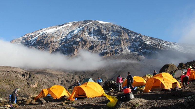
The Machame Route provides impressive views and also a variety of habitats.
The mount Kilimanjaro trek through the Machame route starts at Machame Gate, which is situated at the southern base of mountain, just a short drive from Moshi or Arusha.
The trail then goes through the montane rainforest which is lush and fertile as the lower slopes receive a quite some precipitation. As the trail may be steep and slippery, trekking poles are highly recommended.
When the trail heads toward the Shira Plateau, the trees disappear and are replaced by low brush in the heather zone.
The trail then ascends higher to the volcanic plug, Lava Tower, before descending and circling below the South Icefield. The circular trail, going from Barranco to Karanga, then to Barafu is known as the southern circuit.
The long, strenuous ascent to the summit is done from the east through endless switchbacks up increasingly loose gravel until we reach the crater rim at a mark known as Stella Point. Then the route becomes fairly flat for about an hour to Uhuru Peak, the highest point in Africa.
The relatively quick descent is done through the Mweka route.
In summary, this popular route begins at the Machame gate at the base, then ascends up a steep trail through magnificent forests to a ridge leading through the moorland zones to the Shira Plateau. The trail then passes beneath the glaciated precipices of the Southern Icefields to join the Barafu Route to the summit.
An extra day could be added to the itinerary, best spent on the Shira Plateau, where you could walk to the Shira Needles. Strong groups could omit camping at Karanga River.
Tents are used for accommodation on the Machame Route during the Mount Kilimanjaro trekking.
Upon arrival in Tanzania, guests for Kilimanjaro trekking will be taken to an agreed on lodging facility in either Arusha or Moshi. There will also be a briefing about hiking/ trekking.
The trekking starts in the morning at the Machame gate on the second day. Guests are picked up from the hotel in Arusha or Moshi town at around 8:30 AM and then taken gate.
The route goes through a dense forest of fig and rubber trees, begonia flowers and some other tropical flora. A hike of two to three hours will end at the evening’s campsite. As you continue your ascent, you will find that the tropical forest has given way to tall grasses and giant heather.
Watch your steps as you walk on a ridge, to the left of which is the Semira stream and on the right, the Weru Weru. Depending on the pace of climbers, arrival at Machame Camp is usually between 5 and 6 p.m. Tranquil and relatively easy are the words which best describe the initial stage of this climb.Take time to admire the beauty of the rainforest. Your guides are very knowledgeable about the botany in this area and listening to them will make the walk all the more interesting and rewarding.
Enjoy the fabulous view of Uhuru Peak as it greets you this morning. Today’s trek takes you up a steep track through a savannah of tall grasses, volcanic rock and bearded heather. You will encounter giant groundsels as you hike through an ethereal landscape of volcanic lava, caves and foaming streams.
A trek of approximately six hours will take you to your next campsite; you should arrive between 2 and 3 p.m. Most climbers tend to pace themselves, walking slowly, sipping at their water bottles and resting about every half-hour.
On your 6 a.m. wake-up call today, you will find the entire Shira Plateau at your feet, with sweeping views across to Mount Meru and the Shira Needles. A steady walk takes you up to the pass at Lava Tower (15,000 ft), where you will stop to have lunch. After crossing the Bastains stream, you begin the descent towards Barranco Camp.
Grand Barranco is an immense canyon. Numerous waterfalls, which are fed by streams coming from the mountain, converge here to form the Umbwe River. Your camp is set at almost the same altitude as on the previous night. Today’s trek lasts for about six hours and arrival at camp is between 4.30 and 5.30 p.m.
The day begins with a scramble up the steep ‘Barranco Wall’, and then we trek 3-4 hours and stop in the Karanga Valley for a hot lunch. In the afternoon the trail turns steadily uphill. The temperature will grow colder and the landscape more sparse as we near Barafu Camp. Barafu Camp is set on a small, exposed flat area on a ridge, acting as a base camp from which you will make your summit attempt at midnight tonight. Eat and drink as much as possible before retiring to your tent for rest and sleep.
It is at this stage that the climb becomes much more difficult and hikers should carry as little as possible for this stage which starts at midnight. Temperatures range from -4 degrees to 5 degrees Fahrenheit.
Climbing steadily, flanked by the Ratzel and Rebman glaciers, for about six hours will bring you to the edge of the crater between Stella and Hans Meyer points. Another hour of climbing brings you to the summit.
Concentrate on your feet, and follow your guide very closely for this section of the journey – the track around the edge of the crater is rocky and icy. Uhuru towers at 19,340 ft and is the highest point on the continent of Africa – and this is where you now stand!
Relax and partake of refreshment at Kibo Hut before continuing on to Mweka Camp for the night. Arriving into camp at around 5 p.m. you will look back and realize that, today, you have trekked a total of thirteen hours!
The descent, through the Mweka Route, is relatively short and takes approximately five hours and climbers usually arrive before noon.
Climbers are awarded certificates for the successful conquering of the snowy summit of Africa’s highest mountain, the towering Mount Kilimanjaro.
On the last day of the itinerary, guests are picked up from the hotel and taken to their agreed-upon point of departure.
Copyright © 2026, Trips Tanzania. All rights reserved | Developed by AlgoPage IT Solutions Pvt. Ltd.